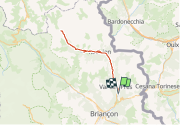
Val des prés - Refuge de Laval

i20
User

Length
50 km

Max alt
2024 m

Uphill gradient
943 m
Km-Effort
62 km

Min alt
1377 m

Downhill gradient
942 m
Boucle
Yes
Creation date :
2021-07-19 10:05:14.767
Updated on :
2021-07-19 15:36:14.688
4h22
Difficulty : Difficult

FREE GPS app for hiking
 SityTrail
IGN / Geographical institutes
SityTrail Plus
The world is yours!
About
Trail Mountain bike of 50 km to be discovered at Provence-Alpes-Côte d'Azur, Hautes-Alpes, Val-des-Prés. This trail is proposed by i20.
Positioning
Country:
France
Region :
Provence-Alpes-Côte d'Azur
Department/Province :
Hautes-Alpes
Municipality :
Val-des-Prés
Location:
Unknown
Start:(Dec)
Start:(UTM)
317205 ; 4978650 (32T) N.
Comments