


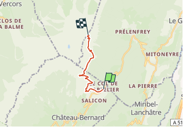
Pzs de l'oeil, col de l'Azelier

jpb83
User

Length
6.4 km

Max alt
1942 m

Uphill gradient
826 m
Km-Effort
14.8 km

Min alt
1149 m

Downhill gradient
50 m
Boucle
No
Creation date :
2021-07-19 19:14:47.139
Updated on :
2021-07-20 07:01:23.185
3h22
Difficulty : Difficult

FREE GPS app for hiking
 SityTrail
IGN / Geographical institutes
SityTrail Plus
The world is yours!
About
Trail Walking of 6.4 km to be discovered at Auvergne-Rhône-Alpes, Isère, Château-Bernard. This trail is proposed by jpb83.
Positioning
Country:
France
Region :
Auvergne-Rhône-Alpes
Department/Province :
Isère
Municipality :
Château-Bernard
Location:
Unknown
Start:(Dec)
Start:(UTM)
704462 ; 4984982 (31T) N.
Comments