


Saintry 29/07/2021

robinier
User

Length
11.5 km

Max alt
51 m

Uphill gradient
98 m
Km-Effort
12.8 km

Min alt
31 m

Downhill gradient
94 m
Boucle
Yes
Creation date :
2021-07-20 06:56:00.0
Updated on :
2021-07-20 10:18:57.022
3h22
Difficulty : Difficult

FREE GPS app for hiking
 SityTrail
IGN / Geographical institutes
SityTrail Plus
The world is yours!
About
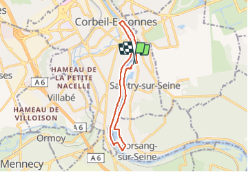
Trail Walking of 11.5 km to be discovered at Ile-de-France, Essonne, Saintry-sur-Seine. This trail is proposed by robinier.
Positioning
Country:
France
Region :
Ile-de-France
Department/Province :
Essonne
Municipality :
Saintry-sur-Seine
Location:
Unknown
Start:(Dec)
Start:(UTM)
462421 ; 5383062 (31U) N.
Comments