


2021 chartres traversée

Mariolebeno
User
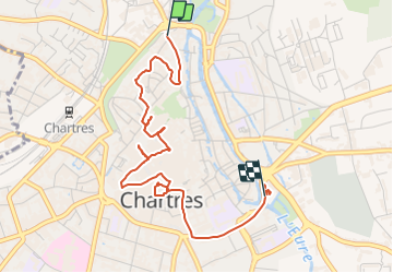

Length
4 km

Max alt
166 m

Uphill gradient
50 m
Km-Effort
4.6 km

Min alt
126 m

Downhill gradient
51 m
Boucle
No
Creation date :
2021-07-20 08:47:38.01
Updated on :
2021-07-20 10:31:31.698
41m
Difficulty : Easy

FREE GPS app for hiking
 SityTrail
IGN / Geographical institutes
SityTrail Plus
The world is yours!
About
Trail Road bike of 4 km to be discovered at Centre-Loire Valley, Eure-et-Loir, Chartres. This trail is proposed by Mariolebeno.
Positioning
Country:
France
Region :
Centre-Loire Valley
Department/Province :
Eure-et-Loir
Municipality :
Chartres
Location:
Unknown
Start:(Dec)
Start:(UTM)
388250 ; 5367699 (31U) N.
Comments