


20210721Prapic

Sugg
User

Length
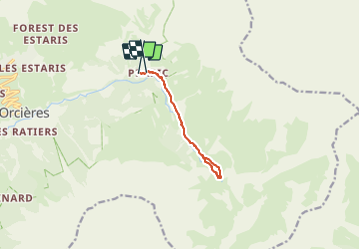
8.8 km

Max alt
1889 m

Uphill gradient
380 m
Km-Effort
13.8 km

Min alt
1538 m

Downhill gradient
355 m
Boucle
No
Creation date :
2021-07-20 08:35:31.118
Updated on :
2021-07-20 13:48:26.305
5h12
Difficulty : Medium

FREE GPS app for hiking
 SityTrail
IGN / Geographical institutes
SityTrail Plus
The world is yours!
About
Trail Walking of 8.8 km to be discovered at Provence-Alpes-Côte d'Azur, Hautes-Alpes, Orcières. This trail is proposed by Sugg.
Description
Le saut du Laire cool Pic nic et trempette des pieds dans le Drac noir .
pas mal de monde qui monte à 15h !!!
beau temps.
Positioning
Country:
France
Region :
Provence-Alpes-Côte d'Azur
Department/Province :
Hautes-Alpes
Municipality :
Orcières
Location:
Unknown
Start:(Dec)
Start:(UTM)
291318 ; 4952217 (32T) N.
Comments