


st aubin

brunobuj
User
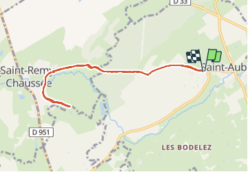

Length
7.8 km

Max alt
176 m

Uphill gradient
118 m
Km-Effort
9.4 km

Min alt
139 m

Downhill gradient
118 m
Boucle
Yes
Creation date :
2021-07-18 08:08:35.438
Updated on :
2021-07-21 14:23:33.425
1h45
Difficulty : Medium

FREE GPS app for hiking
 SityTrail
IGN / Geographical institutes
SityTrail Plus
The world is yours!
About
Trail Walking of 7.8 km to be discovered at Hauts-de-France, Nord, Saint-Aubin. This trail is proposed by brunobuj.
Positioning
Country:
France
Region :
Hauts-de-France
Department/Province :
Nord
Municipality :
Saint-Aubin
Location:
Unknown
Start:(Dec)
Start:(UTM)
565319 ; 5558208 (31U) N.
Comments