Trail Walking Cauterets - Sentier du Lisey - Photo
 ETMU5496
ETMU5496

User

© OpenStreetMap contributors
Length
Length
12.2 km
Max alt
Max alt
1630 m
Uphill gradient
Uphill gradient
730 m
Km-Effort
Km-Effort  
22 km
Min alt
Min alt
909 m
Downhill gradient
Downhill gradient
734 m
Boucle
Boucle
Yes
Creation date :
2021-07-24 09:08:16.0
Updated on :
2021-07-30 12:34:03.894

(0 Reviews)

Walking
Walking
3h28
Difficulty : Medium

Scan this QR Code to open this trail in the SityTrail application

FREE GPS app for hiking

Logo SityTrail SityTrail

IGN / Geographical institutes

Download SityTrail from the App Store Download SityTrail from Google Play

Logo SityTrail SityTrail Plus

The world is yours!

Download SityTrail from the App Store Download SityTrail from Google Play Download SityTrail on Huawei AppGallery

About

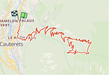
Trail Walking of 12.2 km to be discovered at Occitania, Hautespyrenees, Cauterets. This trail is proposed by ETMU5496.

Description

Depuis le fronton de pelote basque à Cauterets
monter direction auberge de la reine Hortense et arrivés sur la route, se diriger en face vers le sentier du Lisey.
L'emprunter jusqu'à la bifurcation à gauche pour faire une boucle retour par le plateau du Lisey.
nota : possibilité en milieu de parcours, de faire un aller/retour vers le Turon des Oules (Belvédère).

Elevation profile

Photos

Positioning

Country:
France
Region :
Occitania
Department/Province :
Hautespyrenees
Municipality :
Cauterets
Location:
Unknown
Start:(UTM)
735801 ; 4753081 (30T) N.


Close
My subscriptions