


Rocher de l'église

nordan
User
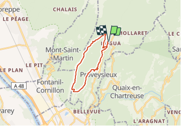

Length
10.1 km

Max alt
1290 m

Uphill gradient
871 m
Km-Effort
22 km

Min alt
566 m

Downhill gradient
870 m
Boucle
Yes
Creation date :
2021-07-24 08:09:14.396
Updated on :
2021-07-24 15:04:42.031
6h54
Difficulty : Very difficult

FREE GPS app for hiking
 SityTrail
IGN / Geographical institutes
SityTrail Plus
The world is yours!
About
Trail Walking of 10.1 km to be discovered at Auvergne-Rhône-Alpes, Isère, Proveysieux. This trail is proposed by nordan.
Positioning
Country:
France
Region :
Auvergne-Rhône-Alpes
Department/Province :
Isère
Municipality :
Proveysieux
Location:
Unknown
Start:(Dec)
Start:(UTM)
712222 ; 5017274 (31T) N.
Comments