


neouvielle depart tournabou

cemoi
User
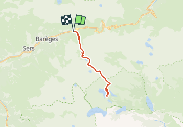

Length
23 km

Max alt
2561 m

Uphill gradient
1559 m
Km-Effort
44 km

Min alt
1439 m

Downhill gradient
1558 m
Boucle
Yes
Creation date :
2021-07-25 07:41:06.591
Updated on :
2021-07-25 07:41:47.454
9h57
Difficulty : Very difficult

FREE GPS app for hiking
 SityTrail
IGN / Geographical institutes
SityTrail Plus
The world is yours!
About
Trail Walking of 23 km to be discovered at Occitania, Hautespyrenees, Barèges. This trail is proposed by cemoi.
Positioning
Country:
France
Region :
Occitania
Department/Province :
Hautespyrenees
Municipality :
Barèges
Location:
Unknown
Start:(Dec)
Start:(UTM)
263103 ; 4754181 (31T) N.
Comments