


Hanches st Lucien poigny

topophil
User
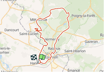

Length
34 km

Max alt
180 m

Uphill gradient
445 m
Km-Effort
40 km

Min alt
109 m

Downhill gradient
443 m
Boucle
Yes
Creation date :
2021-07-25 07:08:37.703
Updated on :
2021-07-25 10:24:16.031
2h41
Difficulty : Difficult

FREE GPS app for hiking
 SityTrail
IGN / Geographical institutes
SityTrail Plus
The world is yours!
About
Trail Mountain bike of 34 km to be discovered at Centre-Loire Valley, Eure-et-Loir, Hanches. This trail is proposed by topophil.
Positioning
Country:
France
Region :
Centre-Loire Valley
Department/Province :
Eure-et-Loir
Municipality :
Hanches
Location:
Unknown
Start:(Dec)
Start:(UTM)
400168 ; 5383864 (31U) N.
Comments