


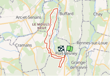
Port-Lesney

geoffrayLayeux
User

Length
13.9 km

Max alt
373 m

Uphill gradient
396 m
Km-Effort
19.2 km

Min alt
240 m

Downhill gradient
396 m
Boucle
Yes
Creation date :
2021-07-25 12:48:49.979
Updated on :
2021-07-25 12:49:32.308
4h22
Difficulty : Very difficult

FREE GPS app for hiking
 SityTrail
IGN / Geographical institutes
SityTrail Plus
The world is yours!
About
Trail Walking of 13.9 km to be discovered at Bourgogne-Franche-Comté, Jura, Port-Lesney. This trail is proposed by geoffrayLayeux.
Positioning
Country:
France
Region :
Bourgogne-Franche-Comté
Department/Province :
Jura
Municipality :
Port-Lesney
Location:
Port-Lesney-Grange-de-Vaivre
Start:(Dec)
Start:(UTM)
714641 ; 5209430 (31T) N.
Comments