


mison

scalpy
User
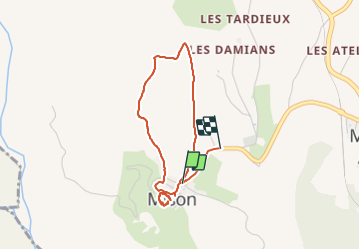

Length
3.6 km

Max alt
682 m

Uphill gradient
61 m
Km-Effort
4.4 km

Min alt
629 m

Downhill gradient
68 m
Boucle
No
Creation date :
2021-07-26 10:46:24.827
Updated on :
2021-07-26 12:11:25.945
54m
Difficulty : Easy

FREE GPS app for hiking
 SityTrail
IGN / Geographical institutes
SityTrail Plus
The world is yours!
About
Trail Walking of 3.6 km to be discovered at Provence-Alpes-Côte d'Azur, Alpes-de-Haute-Provence, Mison. This trail is proposed by scalpy.
Description
petit tour du. gâteau et des champs de lavande. Vues sur la vallée de la Durance et les sommets des Alpes au loin. magnifique et très facile
Positioning
Country:
France
Region :
Provence-Alpes-Côte d'Azur
Department/Province :
Alpes-de-Haute-Provence
Municipality :
Mison
Location:
Unknown
Start:(Dec)
Start:(UTM)
726766 ; 4905177 (31T) N.
Comments