


pissefottd 2

bendoush
User
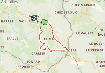

Length
11.5 km

Max alt
790 m

Uphill gradient
289 m
Km-Effort
15.4 km

Min alt
611 m

Downhill gradient
282 m
Boucle
No
Creation date :
2021-07-26 10:40:02.976
Updated on :
2021-07-26 14:48:42.151
4h06
Difficulty : Difficult

FREE GPS app for hiking
 SityTrail
IGN / Geographical institutes
SityTrail Plus
The world is yours!
About
Trail Walking of 11.5 km to be discovered at Auvergne-Rhône-Alpes, Allier, Arfeuilles. This trail is proposed by bendoush.
Positioning
Country:
France
Region :
Auvergne-Rhône-Alpes
Department/Province :
Allier
Municipality :
Arfeuilles
Location:
Unknown
Start:(Dec)
Start:(UTM)
558974 ; 5109198 (31T) N.
Comments