


Lac D'arratille

cemoi
User
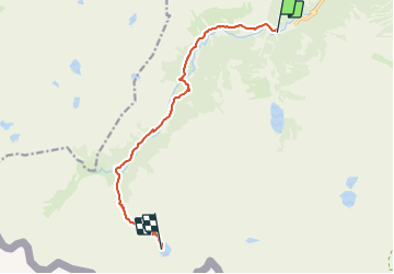

Length
10.7 km

Max alt
2254 m

Uphill gradient
816 m
Km-Effort
19.1 km

Min alt
1500 m

Downhill gradient
65 m
Boucle
No
Creation date :
2021-07-26 19:48:26.518
Updated on :
2021-08-16 08:57:14.699
4h19
Difficulty : Difficult

FREE GPS app for hiking
 SityTrail
IGN / Geographical institutes
SityTrail Plus
The world is yours!
About
Trail Walking of 10.7 km to be discovered at Occitania, Hautespyrenees, Cauterets. This trail is proposed by cemoi.
Positioning
Country:
France
Region :
Occitania
Department/Province :
Hautespyrenees
Municipality :
Cauterets
Location:
Unknown
Start:(Dec)
Start:(UTM)
733694 ; 4748268 (30T) N.
Comments