


valmigere

christinetondeur
User
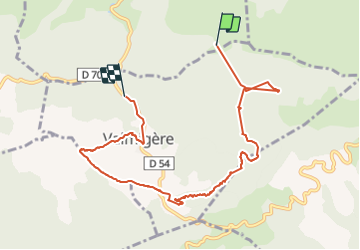

Length
9.2 km

Max alt
903 m

Uphill gradient
272 m
Km-Effort
13.1 km

Min alt
630 m

Downhill gradient
362 m
Boucle
No
Creation date :
2021-07-25 10:54:46.43
Updated on :
2021-07-27 10:57:10.531
3h03
Difficulty : Medium

FREE GPS app for hiking
 SityTrail
IGN / Geographical institutes
SityTrail Plus
The world is yours!
About
Trail Walking of 9.2 km to be discovered at Occitania, Aude, Missègre. This trail is proposed by christinetondeur.
Positioning
Country:
France
Region :
Occitania
Department/Province :
Aude
Municipality :
Missègre
Location:
Unknown
Start:(Dec)
Start:(UTM)
450229 ; 4760347 (31T) N.
Comments