


La Mongie 1

PMarter
User
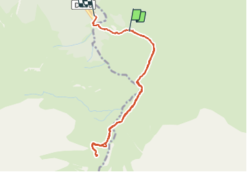

Length
4.5 km

Max alt
1731 m

Uphill gradient
197 m
Km-Effort
7.5 km

Min alt
1417 m

Downhill gradient
311 m
Boucle
No
Creation date :
2021-07-27 11:21:52.595
Updated on :
2021-07-27 13:24:49.733
2h02
Difficulty : Medium

FREE GPS app for hiking
 SityTrail
IGN / Geographical institutes
SityTrail Plus
The world is yours!
About
Trail Walking of 4.5 km to be discovered at Occitania, Hautespyrenees, Campan. This trail is proposed by PMarter.
Positioning
Country:
France
Region :
Occitania
Department/Province :
Hautespyrenees
Municipality :
Campan
Location:
Unknown
Start:(Dec)
Start:(UTM)
272573 ; 4755245 (31T) N.
Comments