


LARGENTIERE

nordan
User
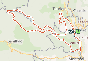

Length
16.5 km

Max alt
495 m

Uphill gradient
639 m
Km-Effort
25 km

Min alt
184 m

Downhill gradient
638 m
Boucle
Yes
Creation date :
2021-07-28 07:24:55.005
Updated on :
2021-07-28 18:00:00.714
10h33
Difficulty : Very difficult

FREE GPS app for hiking
 SityTrail
IGN / Geographical institutes
SityTrail Plus
The world is yours!
About
Trail Walking of 16.5 km to be discovered at Auvergne-Rhône-Alpes, Ardèche, Largentière. This trail is proposed by nordan.
Positioning
Country:
France
Region :
Auvergne-Rhône-Alpes
Department/Province :
Ardèche
Municipality :
Largentière
Location:
Unknown
Start:(Dec)
Start:(UTM)
602642 ; 4932479 (31T) N.
Comments