


Langogne-Ales

Rudy07
User
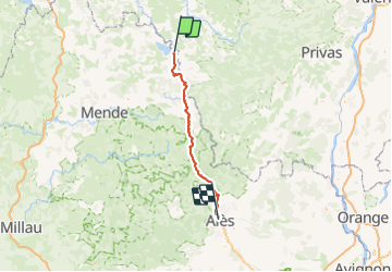

Length
104 km

Max alt
1236 m

Uphill gradient
2371 m
Km-Effort
138 km

Min alt
132 m

Downhill gradient
3145 m
Boucle
No
Creation date :
2021-07-29 07:40:23.475
Updated on :
2023-12-28 14:56:22.824
31h24
Difficulty : Medium

FREE GPS app for hiking
 SityTrail
IGN / Geographical institutes
SityTrail Plus
The world is yours!
About
Trail On foot of 104 km to be discovered at Occitania, Lozère, Langogne. This trail is proposed by Rudy07.
Description
Le retour peut se faire en train.
Positioning
Country:
France
Region :
Occitania
Department/Province :
Lozère
Municipality :
Langogne
Location:
Unknown
Start:(Dec)
Start:(UTM)
567909 ; 4953580 (31T) N.
Comments