


Carantec

gilsep
User
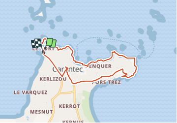

Length
8.3 km

Max alt
50 m

Uphill gradient
148 m
Km-Effort
10.2 km

Min alt
0 m

Downhill gradient
147 m
Boucle
Yes
Creation date :
2021-07-29 07:55:44.0
Updated on :
2021-08-10 16:38:55.058
2h38
Difficulty : Easy

FREE GPS app for hiking
 SityTrail
IGN / Geographical institutes
SityTrail Plus
The world is yours!
About
Trail Walking of 8.3 km to be discovered at Brittany, Finistère, Carantec. This trail is proposed by gilsep.
Description
Jolie promenade sur le littoral de Carantec et passage par le bourg.
Départ du parking de la plage
Positioning
Country:
France
Region :
Brittany
Department/Province :
Finistère
Municipality :
Carantec
Location:
Unknown
Start:(Dec)
Start:(UTM)
432104 ; 5391398 (30U) N.
Comments