


Condé-Sainte-Libiaire

mathis01
User
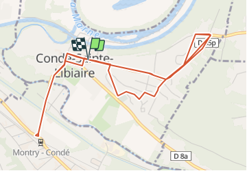

Length
8.4 km

Max alt
88 m

Uphill gradient
100 m
Km-Effort
9.7 km

Min alt
45 m

Downhill gradient
102 m
Boucle
Yes
Creation date :
2021-07-29 13:42:25.242
Updated on :
2021-07-29 13:48:58.05
2h11
Difficulty : Easy
35m
Difficulty : Easy
40m
Difficulty : Easy
19m
Difficulty : Easy

FREE GPS app for hiking
 SityTrail
IGN / Geographical institutes
SityTrail Plus
The world is yours!
About
Trail On foot of 8.4 km to be discovered at Ile-de-France, Seine-et-Marne, Condé-Sainte-Libiaire. This trail is proposed by mathis01.
Positioning
Country:
France
Region :
Ile-de-France
Department/Province :
Seine-et-Marne
Municipality :
Condé-Sainte-Libiaire
Location:
Unknown
Start:(Dec)
Start:(UTM)
487696 ; 5416096 (31U) N.
Comments