


Sainte_Hélène Vosges

JeanPierreNancy
User
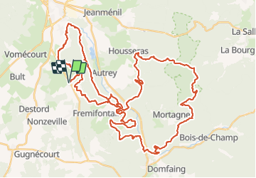

Length
62 km

Max alt
523 m

Uphill gradient
1243 m
Km-Effort
79 km

Min alt
311 m

Downhill gradient
1242 m
Boucle
Yes
Creation date :
2021-07-29 07:52:59.244
Updated on :
2021-07-29 14:09:30.814
5h34
Difficulty : Difficult

FREE GPS app for hiking
 SityTrail
IGN / Geographical institutes
SityTrail Plus
The world is yours!
About
Trail Mountain bike of 62 km to be discovered at Grand Est, Vosges, Sainte-Hélène. This trail is proposed by JeanPierreNancy.
Photos


Positioning
Country:
France
Region :
Grand Est
Department/Province :
Vosges
Municipality :
Sainte-Hélène
Location:
Unknown
Start:(Dec)
Start:(UTM)
326122 ; 5351263 (32U) N.
Comments