


Mauperthuis

mathis01
User
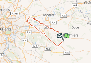

Length
88 km

Max alt
150 m

Uphill gradient
753 m
Km-Effort
98 km

Min alt
39 m

Downhill gradient
752 m
Boucle
Yes
Creation date :
2021-07-29 14:51:33.913
Updated on :
2021-07-30 07:45:15.082
22h16
Difficulty : Very difficult
5h56
Difficulty : Very difficult
6h47
Difficulty : Very difficult
1h36
Difficulty : Very difficult

FREE GPS app for hiking
 SityTrail
IGN / Geographical institutes
SityTrail Plus
The world is yours!
About
Trail On foot of 88 km to be discovered at Ile-de-France, Seine-et-Marne, Mauperthuis. This trail is proposed by mathis01.
Positioning
Country:
France
Region :
Ile-de-France
Department/Province :
Seine-et-Marne
Municipality :
Mauperthuis
Location:
Unknown
Start:(Dec)
Start:(UTM)
502898 ; 5401671 (31U) N.
Comments