Trail Walking Val-d'Aigoual - Cascade d'Orgon depuis Cap de Côte - vue Mont Aigoual - Photo

Cascade d'Orgon depuis Cap de Côte - vue Mont Aigoual

 Bart2015
Bart2015

User

© OpenStreetMap contributors
Length
Length
12.4 km
Max alt
Max alt
1339 m
Uphill gradient
Uphill gradient
356 m
Km-Effort
Km-Effort  
17.2 km
Min alt
Min alt
1074 m
Downhill gradient
Downhill gradient
366 m
Boucle
Boucle
Yes
Creation date :
2021-07-29 08:32:37.605
Updated on :
2021-08-27 10:49:47.126

(0 Reviews)

Walking
Walking
4h34
Difficulty : Medium

Scan this QR Code to open this trail in the SityTrail application

FREE GPS app for hiking

Logo SityTrail SityTrail

IGN / Geographical institutes

Download SityTrail from the App Store Download SityTrail from Google Play

Logo SityTrail SityTrail Plus

The world is yours!

Download SityTrail from the App Store Download SityTrail from Google Play Download SityTrail on Huawei AppGallery

About

Trail Walking of 12.4 km to be discovered at Occitania, Gard, Val-d'Aigoual. This trail is proposed by Bart2015.

Description

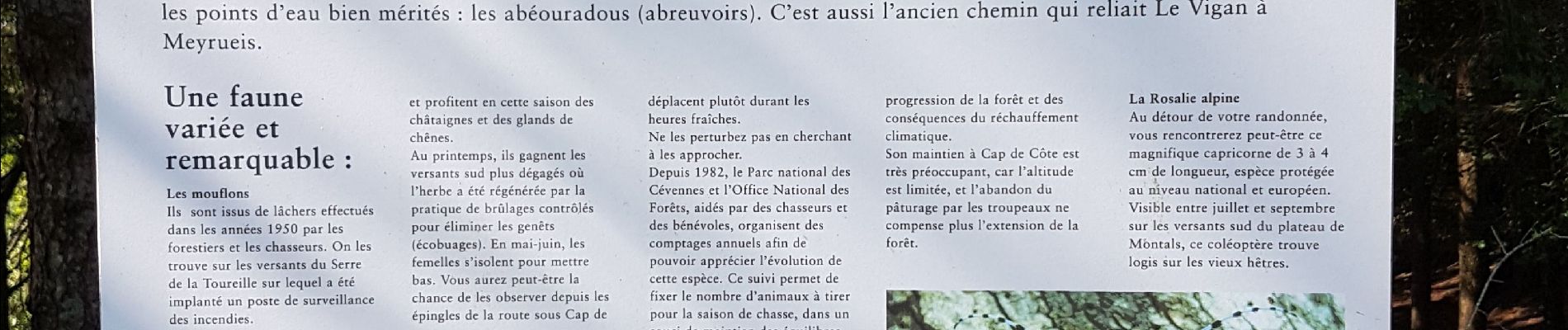
Cette randonnée permet de découvrir par les sentiers la cascade d'Orgon. Elle est visible bien avant d'arriver, soyez observateurs. Ensuite belle vue sur le Mont Aigoual depuis les roches au Col de la Lusette.
Bonne rando ...

Elevation profile

Photos

24 photos in total. Please click on a photo to see them all in the gallery.

Positioning

Country:
France
Region :
Occitania
Department/Province :
Gard
Municipality :
Val-d'Aigoual
Location:
Valleraugue
Start:(UTM)
548728 ; 4877594 (31T) N.


Close
My subscriptions