


Granges - Le Chaluet

pierrepraz
User
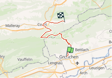

Length
18.5 km

Max alt
1313 m

Uphill gradient
1090 m
Km-Effort
32 km

Min alt
456 m

Downhill gradient
784 m
Boucle
No
Creation date :
2014-12-11 00:00:00.0
Updated on :
2014-12-11 00:00:00.0
--
Difficulty : Unknown

FREE GPS app for hiking
 SityTrail
IGN / Geographical institutes
SityTrail Plus
The world is yours!
About
Trail Other activity of 18.5 km to be discovered at Solothurn, Bezirk Lebern, Grenchen. This trail is proposed by pierrepraz.
Positioning
Country:
Switzerland
Region :
Solothurn
Department/Province :
Bezirk Lebern
Municipality :
Grenchen
Location:
Unknown
Start:(Dec)
Start:(UTM)
378065 ; 5227676 (32T) N.
Comments