


Conches-sur-Gondoire

mathis01
User
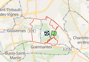

Length
14.6 km

Max alt
111 m

Uphill gradient
197 m
Km-Effort
17.2 km

Min alt
67 m

Downhill gradient
195 m
Boucle
Yes
Creation date :
2021-07-31 08:35:00.061
Updated on :
2021-07-31 08:42:55.665
3h54
Difficulty : Easy
1h02
Difficulty : Easy
1h11
Difficulty : Easy
37m
Difficulty : Easy

FREE GPS app for hiking
 SityTrail
IGN / Geographical institutes
SityTrail Plus
The world is yours!
About
Trail On foot of 14.6 km to be discovered at Ile-de-France, Seine-et-Marne, Conches-sur-Gondoire. This trail is proposed by mathis01.
Positioning
Country:
France
Region :
Ile-de-France
Department/Province :
Seine-et-Marne
Municipality :
Conches-sur-Gondoire
Location:
Unknown
Start:(Dec)
Start:(UTM)
479211 ; 5411505 (31U) N.
Comments