


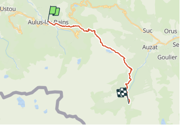
Aulus - Marc/Mounicou

ARVIEU
User

Length
20 km

Max alt
1938 m

Uphill gradient
1428 m
Km-Effort
38 km

Min alt
758 m

Downhill gradient
1088 m
Boucle
No
Creation date :
2021-08-01 13:46:09.157
Updated on :
2021-08-01 13:48:15.02
9h00
Difficulty : Very difficult

FREE GPS app for hiking
 SityTrail
IGN / Geographical institutes
SityTrail Plus
The world is yours!
About
Trail Walking of 20 km to be discovered at Occitania, Ariège, Aulus-les-Bains. This trail is proposed by ARVIEU.
Positioning
Country:
France
Region :
Occitania
Department/Province :
Ariège
Municipality :
Aulus-les-Bains
Location:
Unknown
Start:(Dec)
Start:(UTM)
364201 ; 4738925 (31T) N.
Comments