


devant chez nous

bendoush
User
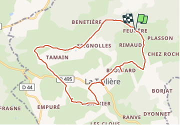

Length
10.1 km

Max alt
834 m

Uphill gradient
281 m
Km-Effort
13.8 km

Min alt
668 m

Downhill gradient
273 m
Boucle
Yes
Creation date :
2021-08-01 12:18:08.929
Updated on :
2021-08-01 14:56:44.406
2h37
Difficulty : Difficult

FREE GPS app for hiking
 SityTrail
IGN / Geographical institutes
SityTrail Plus
The world is yours!
About
Trail Walking of 10.1 km to be discovered at Auvergne-Rhône-Alpes, Loire, La Tuilière. This trail is proposed by bendoush.
Positioning
Country:
France
Region :
Auvergne-Rhône-Alpes
Department/Province :
Loire
Municipality :
La Tuilière
Location:
Unknown
Start:(Dec)
Start:(UTM)
562998 ; 5089631 (31T) N.
Comments