


RAF 2008

pierrepraz
User
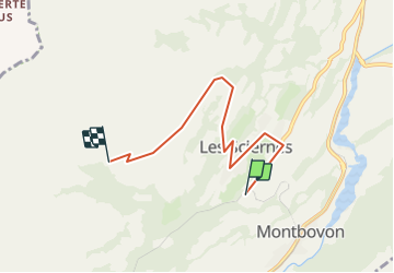

Length
5 km

Max alt
1291 m

Uphill gradient
441 m
Km-Effort
9.5 km

Min alt
873 m

Downhill gradient
30 m
Boucle
No
Creation date :
2014-12-11 00:00:00.0
Updated on :
2014-12-11 00:00:00.0
--
Difficulty : Unknown

FREE GPS app for hiking
 SityTrail
IGN / Geographical institutes
SityTrail Plus
The world is yours!
About
Trail Other activity of 5 km to be discovered at Fribourg, Gruyère District. This trail is proposed by pierrepraz.
Positioning
Country:
Switzerland
Region :
Fribourg
Department/Province :
Gruyère District
Municipality :
Haut-Intyamon
Location:
Unknown
Start:(Dec)
Start:(UTM)
349200 ; 5150560 (32T) N.
Comments