


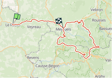
Le mont Aigoual par le col de Perjuret

ARVIEU
User

Length
78 km

Max alt
1560 m

Uphill gradient
3418 m
Km-Effort
123 km

Min alt
388 m

Downhill gradient
3108 m
Boucle
No
Creation date :
2021-08-02 15:15:06.044
Updated on :
2021-08-02 15:17:48.315
4h00
Difficulty : Difficult

FREE GPS app for hiking
 SityTrail
IGN / Geographical institutes
SityTrail Plus
The world is yours!
About
Trail Cycle of 78 km to be discovered at Occitania, Aveyron, Mostuéjouls. This trail is proposed by ARVIEU.
Description
Départ et arrivée depuis Le Rozier.
Circuit empruntant les gorges de la Jonte et passage au col du Perjuret randu célèbre par la chute mortelle du cycliste professionnel Roger Rivière.
Positioning
Country:
France
Region :
Occitania
Department/Province :
Aveyron
Municipality :
Mostuéjouls
Location:
Unknown
Start:(Dec)
Start:(UTM)
516598 ; 4893510 (31T) N.
Comments