


210802 Golf Rouhling

Specialized77
User GUIDE
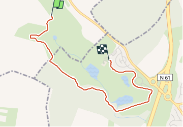

Length
3.5 km

Max alt
268 m

Uphill gradient
38 m
Km-Effort
4.1 km

Min alt
240 m

Downhill gradient
48 m
Boucle
No
Creation date :
2021-08-02 14:42:23.872
Updated on :
2021-08-02 15:54:57.957
1h12
Difficulty : Very easy

FREE GPS app for hiking
 SityTrail
IGN / Geographical institutes
SityTrail Plus
The world is yours!
About
Trail Walking of 3.5 km to be discovered at Grand Est, Moselle, Rouhling. This trail is proposed by Specialized77.
Positioning
Country:
France
Region :
Grand Est
Department/Province :
Moselle
Municipality :
Rouhling
Location:
Unknown
Start:(Dec)
Start:(UTM)
355159 ; 5443475 (32U) N.
Comments