


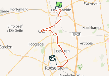
64.116 Lichtervelde - Roeselare (Via Brugensis)

ADL339
User

Length
17.8 km

Max alt
40 m

Uphill gradient
92 m
Km-Effort
19 km

Min alt
14 m

Downhill gradient
96 m
Boucle
No
Creation date :
2021-08-02 18:03:44.0
Updated on :
2021-08-02 18:04:31.315
4h17
Difficulty : Medium

FREE GPS app for hiking
 SityTrail
IGN / Geographical institutes
SityTrail Plus
The world is yours!
About
Trail Walking of 17.8 km to be discovered at Flanders, West Flanders, Lichtervelde. This trail is proposed by ADL339.
Positioning
Country:
Belgium
Region :
Flanders
Department/Province :
West Flanders
Municipality :
Lichtervelde
Location:
Unknown
Start:(Dec)
Start:(UTM)
508879 ; 5652660 (31U) N.
Comments