


20210803 Radepont

Childebert
User
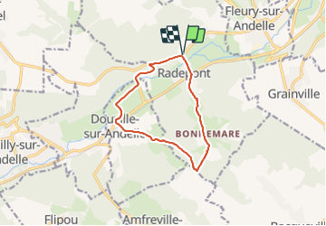

Length
10 km

Max alt
156 m

Uphill gradient
274 m
Km-Effort
13.7 km

Min alt
15 m

Downhill gradient
273 m
Boucle
Yes
Creation date :
2021-08-03 12:00:24.187
Updated on :
2021-08-03 16:34:26.333
3h06
Difficulty : Medium

FREE GPS app for hiking
 SityTrail
IGN / Geographical institutes
SityTrail Plus
The world is yours!
About
Trail Walking of 10 km to be discovered at Normandy, Eure, Radepont. This trail is proposed by Childebert.
Positioning
Country:
France
Region :
Normandy
Department/Province :
Eure
Municipality :
Radepont
Location:
Unknown
Start:(Dec)
Start:(UTM)
378368 ; 5468327 (31U) N.
Comments