


Étang de chandelle Nogent le Roi

topophil
User
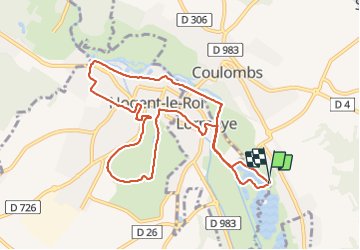

Length
9.9 km

Max alt
135 m

Uphill gradient
69 m
Km-Effort
10.8 km

Min alt
90 m

Downhill gradient
71 m
Boucle
Yes
Creation date :
2021-08-04 07:25:46.025
Updated on :
2021-08-04 09:51:25.853
2h16
Difficulty : Medium

FREE GPS app for hiking
 SityTrail
IGN / Geographical institutes
SityTrail Plus
The world is yours!
About
Trail Walking of 9.9 km to be discovered at Centre-Loire Valley, Eure-et-Loir, Lormaye. This trail is proposed by topophil.
Positioning
Country:
France
Region :
Centre-Loire Valley
Department/Province :
Eure-et-Loir
Municipality :
Lormaye
Location:
Unknown
Start:(Dec)
Start:(UTM)
393301 ; 5388381 (31U) N.
Comments