


17604 TraceGps issued

mitch1952
User
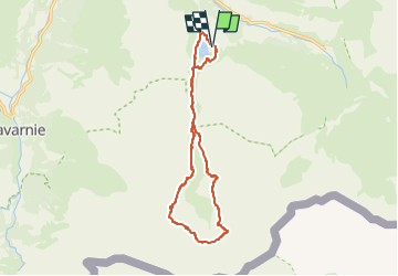

Length
15.4 km

Max alt
2077 m

Uphill gradient
571 m
Km-Effort
23 km

Min alt
1658 m

Downhill gradient
570 m
Boucle
Yes
Creation date :
2021-08-04 11:11:33.263
Updated on :
2022-06-08 14:15:16.798
5h13
Difficulty : Medium

FREE GPS app for hiking
 SityTrail
IGN / Geographical institutes
SityTrail Plus
The world is yours!
About
Trail On foot of 15.4 km to be discovered at Occitania, Hautespyrenees, Gavarnie-Gèdre. This trail is proposed by mitch1952.
Positioning
Country:
France
Region :
Occitania
Department/Province :
Hautespyrenees
Municipality :
Gavarnie-Gèdre
Location:
Gèdre
Start:(Dec)
Start:(UTM)
258756 ; 4737413 (31T) N.
Comments