


longpont/orge

philou91
User
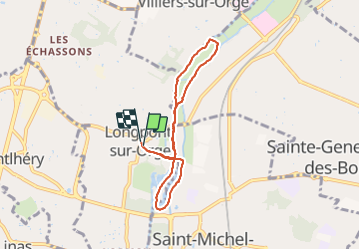

Length
6.2 km

Max alt
59 m

Uphill gradient
58 m
Km-Effort
7 km

Min alt
37 m

Downhill gradient
58 m
Boucle
Yes
Creation date :
2021-08-04 08:25:12.242
Updated on :
2021-08-04 11:12:04.551
2h33
Difficulty : Very easy

FREE GPS app for hiking
 SityTrail
IGN / Geographical institutes
SityTrail Plus
The world is yours!
About
Trail Walking of 6.2 km to be discovered at Ile-de-France, Essonne, Longpont-sur-Orge. This trail is proposed by philou91.
Description
très facile
Photos


Positioning
Country:
France
Region :
Ile-de-France
Department/Province :
Essonne
Municipality :
Longpont-sur-Orge
Location:
Unknown
Start:(Dec)
Start:(UTM)
447877 ; 5387907 (31U) N.
Comments