


nCA-pyVxxaE

zcaiman
User
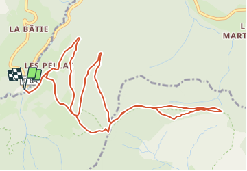

Length
6.9 km

Max alt
1335 m

Uphill gradient
334 m
Km-Effort
11.4 km

Min alt
1101 m

Downhill gradient
334 m
Boucle
Yes
Creation date :
2021-08-05 08:51:25.254
Updated on :
2021-08-05 09:14:51.716
2h35
Difficulty : Medium

FREE GPS app for hiking
 SityTrail
IGN / Geographical institutes
SityTrail Plus
The world is yours!
About
Trail Walking of 6.9 km to be discovered at Auvergne-Rhône-Alpes, Isère, Gresse-en-Vercors. This trail is proposed by zcaiman.


Positioning
Country:
France
Region :
Auvergne-Rhône-Alpes
Department/Province :
Isère
Municipality :
Gresse-en-Vercors
Location:
Unknown
Start:(Dec)
Start:(UTM)
702146 ; 4970528 (31T) N.
Comments