


La Trail

Liebeaux
User

Length
12.7 km

Max alt
2169 m

Uphill gradient
896 m
Km-Effort
25 km

Min alt
1376 m

Downhill gradient
898 m
Boucle
Yes
Creation date :
2021-08-05 06:41:15.216
Updated on :
2021-08-05 15:26:09.998
6h15
Difficulty : Very difficult

FREE GPS app for hiking
 SityTrail
IGN / Geographical institutes
SityTrail Plus
The world is yours!
About
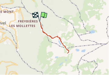
Trail Walking of 12.7 km to be discovered at Auvergne-Rhône-Alpes, Isère, Revel. This trail is proposed by Liebeaux.
Positioning
Country:
France
Region :
Auvergne-Rhône-Alpes
Department/Province :
Isère
Municipality :
Revel
Location:
Unknown
Start:(Dec)
Start:(UTM)
728824 ; 5007807 (31T) N.
Comments