


Jausiers : Jour 5

jlrayon
User
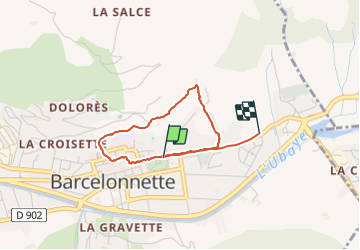

Length
3.1 km

Max alt
1209 m

Uphill gradient
76 m
Km-Effort
4.1 km

Min alt
1138 m

Downhill gradient
73 m
Boucle
No
Creation date :
2021-08-06 09:40:38.884
Updated on :
2021-08-06 11:07:15.735
1h03
Difficulty : Easy

FREE GPS app for hiking
 SityTrail
IGN / Geographical institutes
SityTrail Plus
The world is yours!
About
Trail Walking of 3.1 km to be discovered at Provence-Alpes-Côte d'Azur, Alpes-de-Haute-Provence, Barcelonnette. This trail is proposed by jlrayon.
Positioning
Country:
France
Region :
Provence-Alpes-Côte d'Azur
Department/Province :
Alpes-de-Haute-Provence
Municipality :
Barcelonnette
Location:
Unknown
Start:(Dec)
Start:(UTM)
313277 ; 4917609 (32T) N.
Comments