


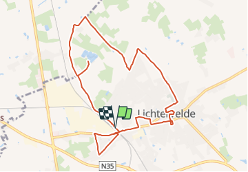
33.486 Lichtervelde - Cichoreiwandeling

ADL339
User

Length
9.8 km

Max alt
29 m

Uphill gradient
51 m
Km-Effort
10.5 km

Min alt
12 m

Downhill gradient
51 m
Boucle
Yes
Creation date :
2021-08-06 13:22:08.0
Updated on :
2021-08-06 13:21:55.052
2h22
Difficulty : Easy

FREE GPS app for hiking
 SityTrail
IGN / Geographical institutes
SityTrail Plus
The world is yours!
About
Trail Walking of 9.8 km to be discovered at Flanders, West Flanders, Lichtervelde. This trail is proposed by ADL339.
Positioning
Country:
Belgium
Region :
Flanders
Department/Province :
West Flanders
Municipality :
Lichtervelde
Location:
Unknown
Start:(Dec)
Start:(UTM)
508946 ; 5652619 (31U) N.
Comments