


sentier de la chapelle. Saint Etienne au mont

tenace
User
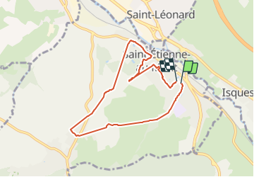

Length
6.9 km

Max alt
117 m

Uphill gradient
207 m
Km-Effort
9.7 km

Min alt
9 m

Downhill gradient
204 m
Boucle
Yes
Creation date :
2021-08-06 13:22:20.278
Updated on :
2021-08-06 16:15:14.984
2h26
Difficulty : Medium

FREE GPS app for hiking
 SityTrail
IGN / Geographical institutes
SityTrail Plus
The world is yours!
About
Trail Walking of 6.9 km to be discovered at Hauts-de-France, Pas-de-Calais, Saint-Étienne-au-Mont. This trail is proposed by tenace.
Positioning
Country:
France
Region :
Hauts-de-France
Department/Province :
Pas-de-Calais
Municipality :
Saint-Étienne-au-Mont
Location:
Unknown
Start:(Dec)
Start:(UTM)
403350 ; 5614927 (31U) N.
Comments