


Montclar

DENNEBECQ
User
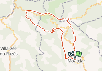

Length
10.2 km

Max alt
404 m

Uphill gradient
272 m
Km-Effort
13.8 km

Min alt
233 m

Downhill gradient
275 m
Boucle
Yes
Creation date :
2021-08-05 07:05:06.27
Updated on :
2021-08-07 06:47:40.794
3h04
Difficulty : Easy

FREE GPS app for hiking
 SityTrail
IGN / Geographical institutes
SityTrail Plus
The world is yours!
About
Trail Walking of 10.2 km to be discovered at Occitania, Aude, Montclar. This trail is proposed by DENNEBECQ.
Positioning
Country:
France
Region :
Occitania
Department/Province :
Aude
Municipality :
Montclar
Location:
Unknown
Start:(Dec)
Start:(UTM)
438741 ; 4776118 (31T) N.
Comments