


BM-08-1-21 du 8.08.2021

bene_dictus77
User
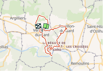

Length
17.5 km

Max alt
100 m

Uphill gradient
244 m
Km-Effort
21 km

Min alt
19 m

Downhill gradient
244 m
Boucle
Yes
Creation date :
2021-08-08 07:34:05.095
Updated on :
2021-08-08 16:05:22.726
6h07
Difficulty : Very easy

FREE GPS app for hiking
 SityTrail
IGN / Geographical institutes
SityTrail Plus
The world is yours!
About
Trail Walking of 17.5 km to be discovered at Occitania, Gard, Vers-Pont-du-Gard. This trail is proposed by bene_dictus77.
Description
Autour du Pont du Gard (30)
Positioning
Country:
France
Region :
Occitania
Department/Province :
Gard
Municipality :
Vers-Pont-du-Gard
Location:
Unknown
Start:(Dec)
Start:(UTM)
622346 ; 4869338 (31T) N.
Comments