


Saint Jacques Lectoure - La Romieu

choubaka77
User
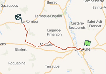

Length
17.7 km

Max alt
220 m

Uphill gradient
352 m
Km-Effort
22 km

Min alt
75 m

Downhill gradient
328 m
Boucle
No
Creation date :
2021-08-09 13:06:12.934
Updated on :
2021-08-09 13:07:32.45
5h03
Difficulty : Very difficult

FREE GPS app for hiking
 SityTrail
IGN / Geographical institutes
SityTrail Plus
The world is yours!
About
Trail Walking of 17.7 km to be discovered at Occitania, Gers, Lectoure. This trail is proposed by choubaka77.
Positioning
Country:
France
Region :
Occitania
Department/Province :
Gers
Municipality :
Lectoure
Location:
Unknown
Start:(Dec)
Start:(UTM)
309272 ; 4867295 (31T) N.
Comments