


Miremont PR (sans la boucle de Beaumont)

pidjam
User
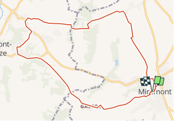

Length
12.1 km

Max alt
287 m

Uphill gradient
170 m
Km-Effort
14.4 km

Min alt
188 m

Downhill gradient
161 m
Boucle
Yes
Creation date :
2021-08-10 06:52:03.008
Updated on :
2021-08-10 06:52:31.172
3h15
Difficulty : Difficult

FREE GPS app for hiking
 SityTrail
IGN / Geographical institutes
SityTrail Plus
The world is yours!
About
Trail Walking of 12.1 km to be discovered at Occitania, Haute-Garonne, Miremont. This trail is proposed by pidjam.
Positioning
Country:
France
Region :
Occitania
Department/Province :
Haute-Garonne
Municipality :
Miremont
Location:
Unknown
Start:(Dec)
Start:(UTM)
371581 ; 4803040 (31T) N.
Comments