Trail On foot Rougon - Les tunnels du couloir Samson et les tours de Trescaïre - Photo

Les tunnels du couloir Samson et les tours de Trescaïre

© OpenStreetMap contributors
Length
Length
2.8 km
Max alt
Max alt
826 m
Uphill gradient
Uphill gradient
470 m
Km-Effort
Km-Effort  
9.1 km
Min alt
Min alt
627 m
Downhill gradient
Downhill gradient
470 m
Boucle
Boucle
Yes
Creation date :
2021-08-10 09:10:56.218
Updated on :
2021-08-10 09:20:55.712

(1 Reviews)

On foot
On foot
3h00
Difficulty : Medium

Scan this QR Code to open this trail in the SityTrail application

FREE GPS app for hiking

Logo SityTrail SityTrail

IGN / Geographical institutes

Download SityTrail from the App Store Download SityTrail from Google Play

Logo SityTrail SityTrail World

The world is yours!

Download SityTrail from the App Store Download SityTrail from Google Play Download SityTrail on Huawei AppGallery

About

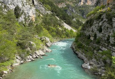
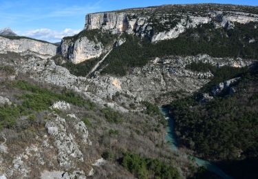
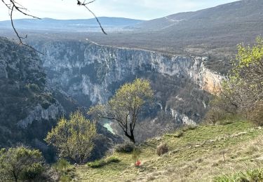
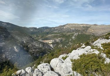
Trail On foot of 2.8 km to be discovered at Provence-Alpes-Côte d'Azur, Alpes-de-Haute-Provence, Rougon. This trail is proposed by jeromelacoste.

Description

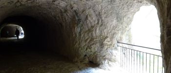
Itinéraire en aller retour qui permet d’accéder au site du couloir Samson qui marque l'entrer du grand canyon. Il vous fera passer par les tunnels du sentier Blanc-Martel jusqu'au belvédère de Trescaïre.
Le sentier emprunte celui de Blanc-Martel, mais est beaucoup plus accessible et vous permettra de faire une balade originale du fait des tunnels.

Elevation profile

Photos

Points of interest

Point of interest La Palud-sur-Verdon - Belvédère de Trescaïre - Photo
jeromelacoste
LA PALUD-SUR-VERDON 
Point of interest La Palud-sur-Verdon - Ancien tunnel - Photo
jeromelacoste
LA PALUD-SUR-VERDON 
Point of interest La Palud-sur-Verdon - tunnel du baou - Photo
jeromelacoste
LA PALUD-SUR-VERDON 

Positioning

Country:
France
Region :
Provence-Alpes-Côte d'Azur
Department/Province :
Alpes-de-Haute-Provence
Municipality :
Rougon
Location:
Unknown
Start:(UTM)
290456 ; 4851804 (32T) N.

Comments

Please log in to post a review or rate the element


Trails nearby

Trail Walking Rougon - Sentier Martel.Gorges du Verdon.06 05 16 - Photo
Walking
Dervalmarc

Walking

Medium
(3)
Rougon, Provence-Alpes-Côte d'Azur, Alpes-de-Haute-Provence, France
12.1 km | 26 km-effort
6h 20min
No
Trail Walking Rougon - Gorges du Verdon - de Point Sublime vers Encastel - AR - Photo
Walking
Orcal37

Walking

Medium
(2)
Rougon, Provence-Alpes-Côte d'Azur, Alpes-de-Haute-Provence, France
9.3 km | 18.6 km-effort
3h 15min
Yes
Trail Walking La Palud-sur-Verdon - Sentier Blanc-Martel - Photo
Walking
i20

Walking

Medium
(2)
La Palud-sur-Verdon, Provence-Alpes-Côte d'Azur, Alpes-de-Haute-Provence, France
15.4 km | 31 km-effort
Unknown
No
Trail Walking La Palud-sur-Verdon - Verdon : Sentier Blanc Martel - Photo
Walking
manumax

Walking

Medium
(1)
La Palud-sur-Verdon, Provence-Alpes-Côte d'Azur, Alpes-de-Haute-Provence, France
16.1 km | 39 km-effort
6h 43min
No
Trail Walking La Palud-sur-Verdon - bastidon - Photo
Walking
xav34830

Walking

Medium
(1)
La Palud-sur-Verdon, Provence-Alpes-Côte d'Azur, Alpes-de-Haute-Provence, France
18.4 km | 33 km-effort
Unknown
Yes
Trail Walking Trigance - Pont du Carajuan Rougon Pont du Tusset Belvédère de Rancoumas Trace réelle - Photo
Walking
jouans

Walking

Very difficult
Trigance, Provence-Alpes-Côte d'Azur, Var, France
21 km | 34 km-effort
7h 40min
Yes
Trail Walking La Palud-sur-Verdon - Chalet de la Maline - Point Sublime - Photo
Walking
LtZIP

Walking

Very difficult
La Palud-sur-Verdon, Provence-Alpes-Côte d'Azur, Alpes-de-Haute-Provence, France
14.4 km | 28 km-effort
6h 19min
No
Trail Walking La Palud-sur-Verdon - Sentier Blanc Martel - Photo
Walking
ETMU5496

Walking

Difficult
La Palud-sur-Verdon, Provence-Alpes-Côte d'Azur, Alpes-de-Haute-Provence, France
15.6 km | 31 km-effort
6h 57min
No
Trail Walking Trigance - Trigance : Rancoumas-Carajuan - Photo
Walking
ETMU5496

Walking

Medium
Trigance, Provence-Alpes-Côte d'Azur, Var, France
16.4 km | 26 km-effort
5h 53min
No


Close
My subscriptions