


yzeron 10 08 21

jtraverse
User
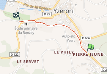

Length
970 m

Max alt
733 m

Uphill gradient
13 m
Km-Effort
1.1 km

Min alt
715 m

Downhill gradient
15 m
Boucle
No
Creation date :
2021-08-11 12:09:27.398
Updated on :
2021-08-11 12:39:25.893
29m
Difficulty : Easy

FREE GPS app for hiking
 SityTrail
IGN / Geographical institutes
SityTrail Plus
The world is yours!
About
Trail Walking of 970 m to be discovered at Auvergne-Rhône-Alpes, Rhône, Yzeron. This trail is proposed by jtraverse.
Positioning
Country:
France
Region :
Auvergne-Rhône-Alpes
Department/Province :
Rhône
Municipality :
Yzeron
Location:
Unknown
Start:(Dec)
Start:(UTM)
624091 ; 5062344 (31T) N.
Comments