


Vienne

meillon
User
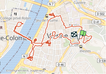

Length
5.4 km

Max alt
235 m

Uphill gradient
104 m
Km-Effort
6.8 km

Min alt
148 m

Downhill gradient
104 m
Boucle
Yes
Creation date :
2021-08-12 10:22:15.693
Updated on :
2021-08-12 15:01:24.426
4h21
Difficulty : Easy

FREE GPS app for hiking
 SityTrail
IGN / Geographical institutes
SityTrail Plus
The world is yours!
About
Trail Walking of 5.4 km to be discovered at Auvergne-Rhône-Alpes, Isère, Vienne. This trail is proposed by meillon.
Description
visite de la ville
Positioning
Country:
France
Region :
Auvergne-Rhône-Alpes
Department/Province :
Isère
Municipality :
Vienne
Location:
Unknown
Start:(Dec)
Start:(UTM)
646655 ; 5042970 (31T) N.
Comments