


Rambouillet, gueville

cemoi
User
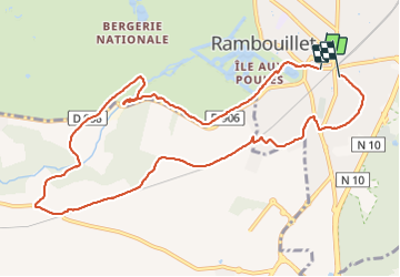

Length
10.7 km

Max alt
177 m

Uphill gradient
123 m
Km-Effort
12.3 km

Min alt
138 m

Downhill gradient
121 m
Boucle
No
Creation date :
2021-08-13 13:47:09.363
Updated on :
2021-08-13 16:12:27.297
2h24
Difficulty : Easy

FREE GPS app for hiking
 SityTrail
IGN / Geographical institutes
SityTrail Plus
The world is yours!
About
Trail Walking of 10.7 km to be discovered at Ile-de-France, Yvelines, Rambouillet. This trail is proposed by cemoi.
Positioning
Country:
France
Region :
Ile-de-France
Department/Province :
Yvelines
Municipality :
Rambouillet
Location:
Unknown
Start:(Dec)
Start:(UTM)
413669 ; 5388392 (31U) N.
Comments