


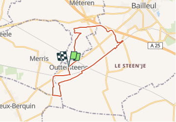
boucle de 13km à OUTTERSTEENE

eaea7charles
User

Length
13.1 km

Max alt
38 m

Uphill gradient
63 m
Km-Effort
13.9 km

Min alt
15 m

Downhill gradient
61 m
Boucle
Yes
Creation date :
2021-08-14 11:55:25.735
Updated on :
2021-08-14 11:57:22.049
3h09
Difficulty : Easy

FREE GPS app for hiking
 SityTrail
IGN / Geographical institutes
SityTrail Plus
The world is yours!
About
Trail On foot of 13.1 km to be discovered at Hauts-de-France, Nord, Bailleul. This trail is proposed by eaea7charles.
Description
BOUCLE FACILE SUR DES CHEMINS GOUDRONNES
Positioning
Country:
France
Region :
Hauts-de-France
Department/Province :
Nord
Municipality :
Bailleul
Location:
Unknown
Start:(Dec)
Start:(UTM)
477551 ; 5617854 (31U) N.
Comments