


nrignais

maclobar
User
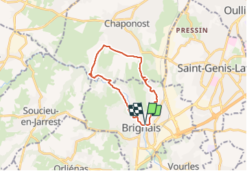

Length
11.3 km

Max alt
324 m

Uphill gradient
173 m
Km-Effort
13.6 km

Min alt
205 m

Downhill gradient
169 m
Boucle
Yes
Creation date :
2021-08-14 08:49:06.103
Updated on :
2021-08-14 13:18:48.873
3h20
Difficulty : Difficult

FREE GPS app for hiking
 SityTrail
IGN / Geographical institutes
SityTrail Plus
The world is yours!
About
Trail Walking of 11.3 km to be discovered at Auvergne-Rhône-Alpes, Rhône, Brignais. This trail is proposed by maclobar.
Positioning
Country:
France
Region :
Auvergne-Rhône-Alpes
Department/Province :
Rhône
Municipality :
Brignais
Location:
Unknown
Start:(Dec)
Start:(UTM)
636768 ; 5059445 (31T) N.
Comments